Official Cumulative Town Count | Unofficial Towns Counted |
118 | 56 |

A couple fun facts:
There are five unincorporated towns in the state of Vermont (2 in the south and 3 in the North East Kingdom). Unincorporated towns have either had their charters revoked by the state legislature or never fully organized due to a lack of residents. Yet, they are considered towns on my VT 251 list (despite the fact they are towns in name only and that their affairs are managed by a state appointed supervisor --not by their local government), and so I needed to at least try to visit them.
In the United States, Vermont has the highest percentage of its roads unpaved (i.e. dirt or gravel).
SOMERSET and GLASTENBURY are the two unincorporated towns in southern Vermont (near Bennington) and both lie almost entirely within the confines of the Green Mountain National Forest, accessible only by dirt road. They were both chartered by Benning Wentworth (Governor of New Hampshire) in 1761 to ensure that New York could not claim the land. Geography of the towns was not a consideration for Wentworth when he drew up the town lines, which is why these two towns, and many others granted by Wentworth are simply (random) squares on the map. Because of this random demarcation, these towns in particular are (and always have been) extremely rugged and difficult to inhabit. I would characterize Somerset as an abandoned town, while Glastenbury has simply vanished into the Green Mountains (and become a ghost town). Both towns were unincorporated in 1937 due to their tiny populations.
SOMERSET


Somerset, VT had a (year-round) population of 6 in 2020 and there is virtually nothing to indicate that it had ever been a fully-developed town or village. It is only accessible by a dirt forest service road (Somerset Road), and while it had a whopping population of roughly 320 in the mid 1850's, all that remains are the cemetery and shell of the one-room school house. Logging was the industry which accounted for that large population figure, and after deforesting the area, the settlers attempted to have log drives down the Deerfield River -- which proved problematic when the river was low (which was often). Then, a railroad line was laid and a lumber mill was constructed and operated until the felled trees were used up, leading to the demise of the logging industry there and therefore the demise of the town of Somerset itself. Then, in 1911, the Deerfield River was considered a potential hydro-power source, and the Somerset Dam was built, creating the current Somerset Reservoir. Apparently there were some miscalculations and the reservoir collected too much water and flooded the then-remnants of the town, railroad tracks and mills.
Today, in summer, the population balloons thanks to several private camps (rustic summer cabins/ homes) and a couple of public and private camping options near the reservoir, one of which used to be an airstrip! The day I visited, there was a summer camp group singing and canoeing at the reservoir, and with the boat launch and picnic tables, Somerset Reservoir is clearly no longer entirely unknown. There is an extensive trail network in Green Mountain National Forest, and the East Branch Trail runs along the east side of Somerset Reservoir, so there is ample hiking available. It's a beautiful and pristine area, and one which I will be visiting again.
GLASTENBURY


Because nearly all the land in Glastenbury, VT falls within the Green Mountain National Forest (and contains 12 mountain peaks exceeding 3,000 feet in elevation), the land within its boundaries is and always has been unsuitable for settlement. Today (ok, well in 2020), the year-round resident population is 9. It is considered by many a ghost town (both because it no longer exists and because it is considered cursed/ mysterious by many people).
There is one dirt road entering Glastenbury (from Shaftsbury), and there are no more than two miles of road in the entire town. Apparently there are 2 distinct areas in the town: Glastonbury and Fayville. Fayville is more easily accessed -- via the dirt Glastenbury Road. The actual ruins of Glastonbury are right off the Appalachian Trail (The Long Trail), not far from the now-closed fire tower atop Glastenbury Mountain (elev. 3748'). It’s quite the hike to get to the actual ruins of Glastonbury -- a 22.3-mile, two-day hike. US Route 7 snakes in and out a couple of times in the northwest corner of town (where it hits its highest elevation) -- see picture of town boundaries above, with signs telling you that you are in Glastenbury; otherwise there is no signage.
We drove the dirt road for as long as I thought my car could manage and then started walking on what I assume was the old railroad bed. After a mile and a half, according to Google, we "arrived" at Glastenbury -- a clearing near Bolles Brook which I assume must have been Fayville. I suspect had we continued on for a few more miles we might have found some evidence (like a brick or railroad tie) of the town of South Glastenbury -- the terminus of the railroad and where the hotel, casino, and other buildings once stood. But it was getting late and I was concerned my car might be trashed as there is no official parking and I left it on someone's land... [It was fine.] Clearly, some folks really want privacy and (I suspect) amazing views as we passed several private homes along the dirt road, some quite impressive (think: tennis court, swimming pool, herb gardens) and some not, before the "road" turned rougher and narrower at a sign saying that the public highway was a trail which the town does not maintain (ie driver beware -- and no ATVs) -- this was where I stopped driving.
A Little History
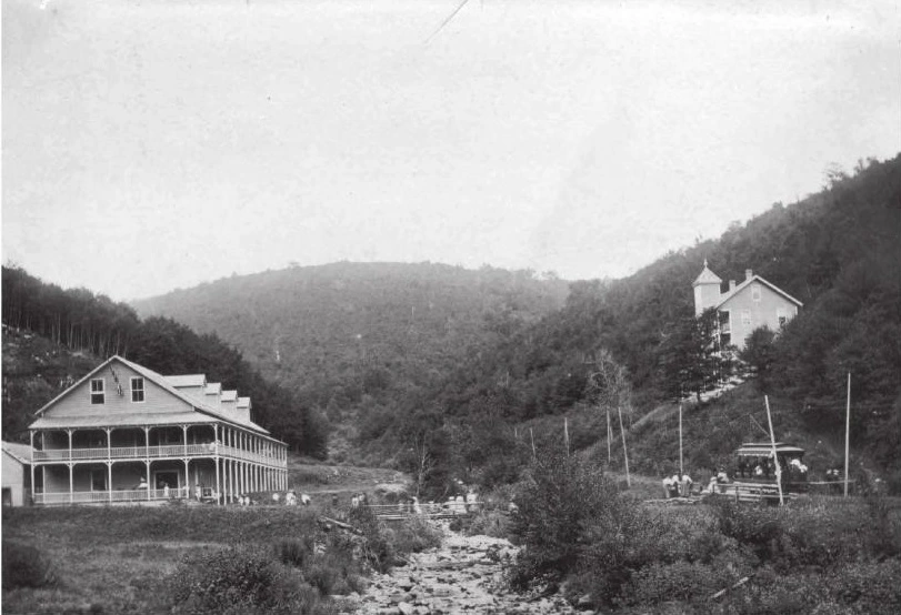
Like Somerset, Glastenbury had a lot of wood to burn, and charcoal burning was the primary business there for years. In its support, the Glastenbury-Woodford-Bennington railroad was built in 1872, and trains of 12-14 cars traveled between (South) Glastenbury and Bennington every day carrying lumber, charcoal, alcohol and a few passengers up 1300 feet of vertical elevation in less than 9 minutes. Once the mountains were stripped of all their mature trees, the charcoal business was wiped out.
The railroad was then converted into an electric trolley which ran up the mountain daily as investors tried to recoup their losses by converting old loggers’ quarters and worksites into a summer resort for wealthy vacationers. Many structures were built for the visitors (clubhouse with dance hall and dining room, an inn, a casino with clock tower, etc.) and by the time the town's population peaked in the late 1880's (241 residents), the town included a post office, small houses and a school. A flood washed away the railroad tracks in 1898 after just one season of hosting guests, and the settlement of South Glastenbury became a ghost town.
Ghost Town Lore
The vast wilderness that is Glastenbury is host to many legends and lore which include a cursed forest, big hairy monsters, a cursed Indian stone that swallows humans, UFOs, and mysterious lights, sounds and odors detected by colonial settlers. Plus, numerous hikers disappeared off the face of the earth in Glastenbury between 1945 to 1950 – earning it the nickname “The Bennington Triangle,” and leading directly to the formation of the Vermont State Police in 1947. While it is possible some of the folks who disappeared could have fallen down sinkholes (which are not uncommon in that area), nobody can know for certain what really happened to them. Here's a link to a video should you want more detail about Glastenbury's ghost town reputation: https://www.onlyinyourstate.com/vermont/ghost-town-vt/.
More towns coming your way next week. Towns in which people live and roads cross, that is.
Comments